Maharashtra Board Class 12 Geography Important Questions 2027 (Repeated in Board Exams)
79 question patterns that appeared in two or more of the analysed papers (7 past board papers (2023–2026)). The numbers change; the question does not.
Human Geography: Nature and Scope
1. Skills of a geographer
5×Board 2023Board 2024Board 20261/2/4 marks
Skills of a geographer - Identify incorrect factor: (a) Observation (b) Map making (c) Data Collection (d) Communication skills
2. Write a note on the nature of geography
3×Board 2025Board 20264 marks
Write a short note on: Nature of geography.
3. Differentiate: Human geography vs Physical geography
3×Board 2024Board 20263 marks
Differentiate between Physical geography and Human geography
4. Scholars and classical works of geography
4×Board 2023Board 20241 marks
Identify the incorrect factor - Scholars of geography: (A) Hecataeus (B) Ptolemy (C) Shakespeare (D) Strabo
5. Correlation chain: branches of geography
3×Board 2023Board 2024Board 20261 marks
Complete the co-relation chain across columns 'A','B','C' - A: Physical Geography
6. Identify incorrect: branches/factors of physical geography
2×Board 2024Board 20251 marks
Identify the incorrect factor - Factors studied in physical geography: (a) Atmospheric factors (b) Relief (c) Lakes (d) Transport
7. Nature of geography / its factors are dynamic
2×Board 2023Board 20251 marks
Identify the correct co-relation - A: Physical or human factors are not static but highly dynamic; they change over time. R: The earth is dynamic; we find variations in its physical and cultural environments. Options: (A) Only A correct (B) Only R correct (C) Both correct, R explains A (D) Both correct, R does not explain A
8. Draw diagram: relationship of geography with other subjects
2×Board 2023Board 20252 marks
Draw a neat labelled diagram: Relationship of Geography with other subjects
Population: Distribution and Density
9. Human factors affecting population distribution
5×Board 2024Board 2025Board 20261/8 marks
Choose the correct option - Human factors affecting the distribution of population: (A) Climate (B) Soils (C) Transportation (D) Relief
10. Impact of climate on population distribution
2×Board 2025Board 20263/4 marks
Write a short note on: Impact of climate on population distribution.
11. Geographical reason: mountainous/Himalaya region is sparsely populated
2×Board 2024Board 20263 marks
Give geographical reason: Himalaya mountain region have low population.
12. Impact of relief on population distribution
2×Board 2023Board 20251/4 marks
Identify the incorrect factor: (a) Plains (b) Lakes (c) Plateaus (d) Mountains
13. Population distribution is uneven / not the same everywhere
2×Board 2023Board 20241/3 marks
Give geographical reason: Population distribution is uneven.
Population: Structure and Change
14. Literacy rate is an indicator of socio-economic development
5×Board 2024Board 2025Board 20261/3 marks
True or False: Literacy rate is an indicator of a country's development.
15. Correlation chain: migration
3×Board 2024Board 20261 marks
Complete the co-relation chain across columns 'A','B','C' - A: Migration
16. Assertion-reason: pyramid broad base = children, broad apex = elderly
2×Board 2025Board 20261 marks
A: Broad based population pyramid indicates more children in the population. R: Broad apex is an indicator of high number of elders in the population. Options: (A) Only A correct (B) Only R correct (C) Both correct, R explains A (D) Both correct, R does not explain A
17. Correlation between birth rate and death rate
2×Board 2025Board 20264 marks
Write a short note on: Correlation between birth rate and death rate
18. Migration is a component of population change
2×Board 2024Board 20261 marks
True or False: Migration is not a component of population change.
19. Reasons for migration
2×Board 2024Board 20261/4 marks
Write a short note on: Reasons for migration
20. Differentiate: Demographic transition Stage 1 vs Stage 5
2×Board 2023Board 20253 marks
Differentiate between Demographic Transition Theory Stage 1 and Stage 5
21. Draw diagram: Stationary population pyramid
2×Board 2023Board 20252 marks
Draw a neat labelled diagram: Stationary Pyramid
22. Differentiate: Expansive vs Constrictive pyramid
2×Board 2023Board 20243 marks
Distinguish between Expansive pyramid and Constrictive pyramid.
23. Draw diagram: Demographic Transition Theory
2×Board 2023Board 20242 marks
Draw a neat labelled diagram: First and second stages of Demographic Transition Theory.
Human Settlements
24. Rural land use is related to agriculture
4×Board 2024Board 2025Board 20261/3/4 marks
Give geographical reason: In rural settlements, land use is related to agriculture.
25. Functional classification of settlements
3×Board 2024Board 20261/4 marks
True or False: Settlements can not be classified according to functions.
26. Correlation chain: administrative city
2×Board 2025Board 20261 marks
Complete the co-relation chain across columns 'A','B','C' - A: Administrative cities
27. Physical factors affect settlement location
2×Board 2025Board 20261 marks
A: Settlements are of various types. R: Various physical factors affect the development of settlements. Options: (A) Only A correct (B) Only R correct (C) Both correct, R explains A (D) Both correct, R does not explain A
28. Arrange settlements by population size
2×Board 2025Board 20261 marks
According to size, arrange the settlements from large to small: (a) Suburb (b) Megacity (c) City (d) Metro-city
29. Draw diagram: Linear settlement pattern
2×Board 2024Board 20262 marks
Draw a neat labelled diagram: Linear Settlement
30. Differentiate: Nucleated vs Dispersed settlement
2×Board 2023Board 20243 marks
Differentiate between Nucleated and Dispersed settlement.
Primary Activities
31. Characteristics of extensive commercial grain farming
4×Board 2024Board 2025Board 20261/8 marks
Choose the correct option - A major crop of extensive commercial agriculture: (A) coffee (B) wheat (C) rice (D) medicinal plants
32. Factors / ideal location for fishing
3×Board 2025Board 20261/4 marks
Ideal location for fishing fields: (a) rugged coasts, shallow seas, hot climate, growth of planktons (b) shallow seas, confluence of warm and cold ocean currents, growth of planktons, cold climate (c) continental shelf, growth of planktons, good skill of fishing, warm climate (d) continental shelf, broken coasts, growth of planktons, warm climate
33. Geographical reason: extensive agriculture is a commercial type
2×Board 2025Board 20263 marks
Give geographical reason: Extensive agriculture is a commercial type of agriculture.
34. Shifting agriculture
2×Board 2024Board 20251/4 marks
Complete the co-relation chain across columns 'A','B','C' - A: Shifting agriculture
35. Commercial lumbering is carried in temperate not equatorial forests
2×Board 2024Board 20251 marks
Identify the correct co-relation - A: Hardwood trees are found in equatorial evergreen forest. R: Lumbering is not developed on a commercial level in equatorial regions. Options: (A) Only A correct (B) Only R correct (C) Both correct, R explains A (D) Both correct, R does not explain A
36. Primary activity not directly related to latitude
2×Board 2023Board 20241 marks
Identify the incorrect factor - Primary economic activity not related directly to latitude: (a) Lumbering (b) Fishing (c) Mining (d) Agriculture
37. Geographical reason: lumbering is developed on a large scale in Canada
2×Board 2023Board 20243 marks
Give geographical reason: Lumbering is developed on a large scale in Canada.
38. Answer in detail: intensive subsistence agriculture
2×Board 2023Board 20248 marks
Answer in detail: Explain intensive subsistence agriculture in detail.
Secondary Activities
39. Arrange industries by capital investment
4×Board 2023Board 2025Board 20261 marks
Arrange the industries in descending order according to the high capital investment: (a) Carpentry (b) Iron and steel industry (c) Toy making industry (d) Milk processing industry
40. Industry location: raw-material vs market orientation
3×Board 2024Board 20261 marks
True or False: Sugar industries are located near raw material producing area.
41. Geographical reason: distribution of industries is uneven
2×Board 2025Board 20263 marks
Give geographical reason: Distribution of industries is uneven in the world.
42. Classification of industries by ownership
2×Board 2024Board 20261/4 marks
Write a short note on: Classification of industries based on ownership.
43. Geographical reason: fruit-processing industries in Ratnagiri/Sindhudurg Konkan
2×Board 2023Board 20263 marks
Give geographical reason: Fruit processing industries are found in Ratnagiri and Sindhudurg Districts of Konkan region.
44. Answer in detail: factors affecting location of industries
2×Board 2023Board 20268 marks
Answer in detail: Explain the factors affecting the location of industries.
45. Assertion-reason: India industrial concentration and agrarian economy
2×Board 2024Board 20251 marks
Identify the correct co-relation - A: In India, industrial areas are found concentrated in few regions. R: India is agricultural country. Options: (A) Only A correct (B) Only R correct (C) Both correct, R explains A (D) Both correct, R does not explain A
46. Classification of industries by source of raw material
2×Board 2024Board 20254/8 marks
Answer in detail: Explain in detail the classification of industries based on the source of raw material.
47. Mineral-based industries
2×Board 2024Board 20251 marks
Choose the correct option - Mineral Based Industries: (A) Iron and steel industries (B) Textile industries (C) Sugar industries (D) Food Processing industries
48. Footloose industries
2×Board 2024Board 20251/4 marks
Identify the incorrect factor - Footloose industries: (a) Cement industries (b) Clock making industries (c) Diamond cutting industries (d) Hairpin making industries
49. MCQ: NE USA industrial region (iron-ore and coal)
2×Board 2023Board 20251 marks
Choose the correct option - In USA, industrial areas are found in North-Eastern region because: (A) dense population (B) availability of capital (C) availability of rich deposits of coal and iron-ore (D) centralization of transport route
Tertiary Activities
50. Identify tertiary activities among examples
4×Board 2025Board 20261 marks
Identify the tertiary activity: (a) Hunting (b) Agriculture (c) Trade (d) Cotton textile industry
51. Differentiate: Waterways vs Airways
3×Board 2024Board 2025Board 20263 marks
Differentiate between Waterways and Airways
52. Tertiary activities include both services and exchange
3×Board 2023Board 20241/3 marks
True or False: Tertiary activities include only services.
53. Write a note on means of communication
2×Board 2024Board 20264 marks
Write a short note on: Means of communication
54. Geographical diversity is responsible for trade
2×Board 2023Board 20261/3 marks
Give geographical reason: Geographical diversity is responsible for trade to occur.
55. Write a note on role of transportation in trade
2×Board 2023Board 20244 marks
Write a short note on: Role of transportation in trade
Region and Regional Development
56. Regional development depends on physical setting / physical factors
6×Board 2023Board 2024Board 2025Board 20261/3 marks
Give geographical reason: Physical factors are most important for regional development.
57. Differentiate: Donor region vs Recipient region
3×Board 2024Board 20263 marks
Differentiate between Donor region and Recipient region
58. Causes of regional imbalance in India
3×Board 2024Board 2025Board 20264 marks
Write a short note on: Factors affecting regional imbalance in India
59. Draw diagram: provision of goods/services/infrastructure to reduce imbalance
3×Board 2024Board 2025Board 20262 marks
Draw a neat labelled diagram: Provision of public goods / services to reduce regional imbalance
60. Differentiate: Physical region vs Political region
3×Board 2024Board 20253 marks
Differentiate between Physical Region and Political Region
61. MCQ: identify a functional region
2×Board 2024Board 20261 marks
Choose the correct option - Functional region: (A) Pune Metropolitan (B) Latur (C) Satara (D) Amravati
62. Write a note on strategies to reduce regional imbalance
2×Board 2024Board 20264 marks
Write a short note on: Strategies to reduce regional imbalance.
63. Geographical reason: illiteracy and poverty affect regional development
2×Board 2024Board 20253 marks
Give geographical reason: Factors like illiteracy, poverty affect the regional development.
Geographic Skills
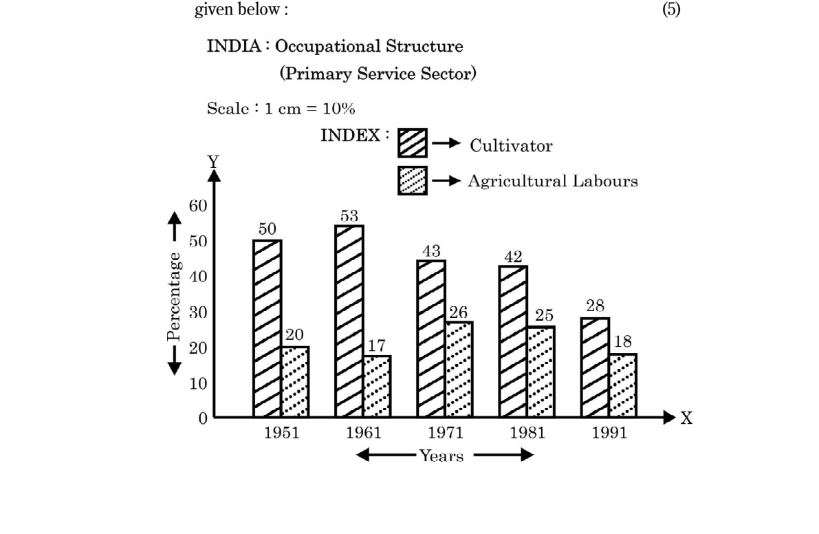
64. Observe occupational/economic structure graph and answer
10×Board 2023Board 20251 marks
[Observe the India Occupational Structure graph 1951-1991] What is shown in the above graph?
65. Map of world: population distribution / density region
8×Board 2023Board 2024Board 2025Board 20261 marks
Mark and name on the outline map of the world: A country having highest density of population in Asia.
66. Map of world: industrial region
7×Board 2023Board 2024Board 2025Board 20261 marks
Mark and name on the outline map of the world: Perth - an industrial region.
67. Map of world: city by function (mega/commercial/administrative)
5×Board 2023Board 2024Board 2025Board 20261 marks
Mark and name on the outline map of the world: Commercial City in the USA.
68. Map of world: canal / ship canal
5×Board 2023Board 2024Board 20251 marks
Mark and name on the outline map of the world: Suez Canal
69. Map of world: grassland / animal-husbandry area
4×Board 2024Board 2025Board 20261 marks
Mark and name on the outline map of the world: A region in South America where animal husbandry is practised on commercial scale.
70. Map of world: fishing area
3×Board 2024Board 2025Board 20261 marks
Mark and name on the outline map of the world: Grand Bank fishing area.
71. Map of world: sex-ratio country/state
3×Board 2023Board 2024Board 20261 marks
Mark and name on the outline map of the world: The country having highest sex-ratio in the world - Russia.
72. Correlation chain: map-making / geospatial technology
2×Board 2025Board 20261 marks
Complete the co-relation chain across columns 'A','B','C' - A: Making maps
73. Map of world: intercontinental airway route
2×Board 2025Board 20261 marks
Mark and name on the outline map of the world: Mumbai to London airway.
74. Map of world: major river basin
2×Board 2025Board 20261 marks
Mark and name on the outline map of the world: Nile river basin.
75. Arrange given places by geographical location (E-W / W-E)
2×Board 2023Board 20261 marks
Arrange the countries on the basis of their location from West to East: (a) France (b) India (c) Japan (d) U.S.A.
76. Map of world: mining / oil-producing area
2×Board 2023Board 20261 marks
Mark and name on the outline map of the world: Oil producing country in South America - Venezuela.
77. Map of world: intercontinental railway route
2×Board 2023Board 20261 marks
Mark and name on the outline map of the world: Trans Australian Railway route.
78. Map of world: country with given life expectancy
2×Board 2024Board 20251 marks
Mark and name on the outline map of the world: A country having highest life expectancy: Japan
79. Map of world: country in a demographic transition stage
2×Board 2023Board 20251 marks
Mark and name on the outline map of the world: An African country in second phase of demographic transition.